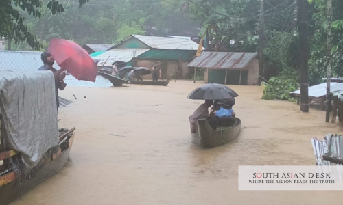
Bandarban floods have stranded thousands of families after four days of heavy rainfall and hill runoff submerged large parts of the southeastern Bangladesh district, forcing more than 2,600 people to take shelter.
The district administration has opened 220 emergency shelters as floodwaters spread through low-lying neighbourhoods, riverbank settlements and residential areas. Officials have instructed local authorities to evacuate residents from flood and landslide-prone zones and provide food and essential supplies to displaced families.
The situation has worsened as rivers in the district crossed danger levels and continuous rainfall increased the risk of flash floods, landslides and further displacement. Authorities have also extended the closure of tourist attractions until July 12, citing public safety concerns.
Bandarban floods force residents into shelters
Bandarban floods have affected several neighbourhoods in Bandarban municipality, including Hafezghona, Kalaghata, Kyangchingghata, Balaghata, Barilal Para, the Marma Bazar riverbank, Kashem Para and Member Para.
In some areas, floodwaters reportedly reached waist to neck level, leaving families trapped in their homes or forcing them to move quickly to safer places. Many residents shifted to shelters, while others set up temporary roadside huts to protect household belongings they could not carry away.
Local officials said emergency food support would be distributed among displaced families. Educational institutions being used as shelters or damaged by flooding are expected to remain temporarily closed.
The displacement has created immediate humanitarian needs, including food, clean water, temporary accommodation, sanitation and medical support. In flood-affected hill districts, access can become difficult when roads are damaged, communication is disrupted and rainfall continues.
Heavy rainfall pushes rivers above danger levels
The flooding has been driven by intense rainfall and runoff from surrounding hills. Bandarban recorded 210 millimetres of rainfall in the 24 hours ending at 6:00pm, a level classified locally as very heavy rainfall.
Two major rivers in the district have crossed danger levels. The Matamuhuri River was flowing at 11.98 metres, above its danger mark of 11.80 metres. The Sangu River reached 16.06 metres, far higher than its danger level of 14.80 metres.
These river levels explain why flooding spread quickly through low-lying areas. When upstream rainfall combines with hill runoff, water can rise rapidly in valleys and riverbank communities. This leaves residents with little time to move belongings or evacuate safely.
The danger is not limited to flooding. In hill districts such as Bandarban, prolonged rainfall also saturates slopes, increasing the possibility of landslides. This is especially dangerous in areas where homes, roads and community buildings are located near unstable hillsides.
Landslide risk adds to emergency concerns
The risk of landslides remains one of the most serious concerns in Bandarban. Continuous rainfall weakens soil and can trigger sudden slope collapses, particularly in hilly settlements and along roads.
Officials have directed evacuations from vulnerable areas, but moving people away from high-risk locations can be difficult. Some families are reluctant to leave their homes because of fears over theft, loss of property or uncertainty about shelter conditions.
The wider Chittagong Hill Tracts region is regularly exposed to monsoon hazards. Heavy rain, steep terrain, poor drainage and settlements near slopes create recurring risks during the rainy season. Even when floodwaters begin to recede, the ground can remain unstable, keeping the landslide threat high.
The current emergency therefore requires more than short-term shelter arrangements. Authorities will need to continue monitoring slopes, river levels and road conditions until rainfall eases and affected communities can safely return.
Tourist attractions closed as safety risks grow
The Bandarban district administration has extended the closure of all tourist attractions until July 12 because of persistent rainfall, flash flood risks and landslide concerns.
The decision is significant because Bandarban is one of Bangladesh’s major hill tourism destinations, known for rivers, waterfalls, hills and remote natural sites. However, many tourist routes pass through landslide-prone roads or areas that can become dangerous during intense monsoon rain.
Closing tourist spots is intended to prevent visitors from becoming stranded or exposed to hazards in remote locations. Earlier rainfall had already disrupted movement in parts of the district, and authorities have warned residents and travellers to follow safety instructions.
The closure will affect local tourism businesses, but public safety is likely to remain the priority while rivers remain swollen and rainfall continues.
Flooding exposes vulnerability of hill districts
The latest Bandarban floods highlight the vulnerability of Bangladesh’s hill districts to climate and weather-related disasters. These areas face a combination of steep terrain, riverine flooding, fragile slopes and limited emergency access.
Monsoon flooding is not unusual in Bangladesh, but hill districts experience a distinct pattern of risk. Rainfall can rapidly collect in streams and rivers, while runoff from hills can flood settlements with little warning. Landslides can also block roads and isolate communities.
Urban growth and settlement expansion have added to the danger. Homes and community structures built close to hillsides or riverbanks are more exposed when extreme rainfall occurs. Drainage systems may also struggle to handle sudden water flow during prolonged downpours.
The current flooding shows why early warning, planned evacuation, safer shelter access and slope management are essential for disaster preparedness in Bandarban and other hill districts.
Relief response must remain urgent
The immediate priority is to protect stranded residents, maintain shelter support and prevent further casualties. Authorities will need to ensure that shelters have adequate food, drinking water, sanitation facilities and medical assistance, especially for children, older people and vulnerable families.
Flood response teams will also need to monitor waterborne disease risks if flooding persists. Stagnant water, damaged sanitation systems and crowded shelters can increase health concerns after several days of displacement.
Longer-term recovery may take time. Families whose homes were submerged may need assistance to clean, repair or rebuild. Schools used as shelters may also require repairs before classes can resume.
For now, Bandarban remains under pressure from very heavy rainfall, swollen rivers and heightened landslide risks. The movement of more than 2,600 people into shelters shows the scale of the emergency, while the closure of tourist attractions underlines the continuing danger.
The coming days will be crucial. If rainfall continues, more families may need evacuation. If water levels fall, authorities will still face the difficult task of helping displaced residents return safely and assessing damage across flood-hit communities.
Published in SouthAsianDesk, July 9, 2026
Follow SouthAsianDesk on X, Instagram and Facebook for insights on business and current affairs from across South Asia.