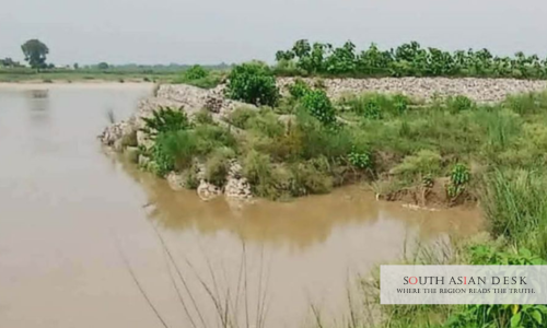
Babai river erosion has placed five villages in Gulariya Municipality-10, in Nepal’s Bardiya district, at high risk after rising water levels triggered fresh damage to the riverbanks on Tuesday. As the water receded, the river began cutting into its banks, exposing the settlements of Ratnapur, Jhagarupur, Rangipur, Nayapur and Mahajadiya to growing danger. Residents fear that a major flood could inundate the villages and destroy farmland if action is not taken soon.
The damage has intensified at a site near the Nepal-India border where embankment construction was halted after objections were raised from the Indian side, according to the office that previously managed the Babai, Bhada and Aurahi river systems in Bardiya. Southern embankments built earlier by that office have also come under growing threat from the erosion.
What Is Driving the Babai River Erosion
A farmer from Ratnapur said the stalled embankment work had allowed the river to shift course, leaving the five villages more exposed than before, and called for authorities to move quickly to complete construction in the affected area. The concern is shared widely in the area, where residents say the river has been gradually changing course due to erosion along its southern side, steadily raising the risk to nearby settlements.
Much of the disruption traces back to an administrative decision. The office responsible for embankment work in the area had planned further construction, but the project was relocated to Dadeldhura last year, interrupting flood-control efforts that remain incomplete. Responsibility for the office’s duties has since passed to the Irrigation and Water Resource Management Project, formerly known as the Karnali River Management Project, based in Rajapur. The project’s chief said he had not been formally notified of the erosion but planned to visit the site and take preventive steps, noting that confusion over which office now holds responsibility for the area may have delayed the flow of information.
Years of Land Loss and Repeated Warnings
The erosion is not a new problem for the area. One local farmer said more than 40 bighas of cultivable land had been washed away over the past seven years, while another resident pointed out that three boundary pillars marking the Nepal-India border near the villages were swept away by the river five years ago. With the monsoon season continuing until October, residents say the threat to farmland remains high, and many fear a repeat of the destructive floods that struck the area in 2014 and 2017.
The five villages sit close to the Nepal-India border and depend heavily on agriculture, producing paddy, mustard, wheat, vegetables and maize. Residents have long called for a permanent embankment to control the river’s erosion, and construction had originally been planned to begin in the last fiscal year before the responsible office was relocated and the work left unfinished. Locals say that without renewed support and a clear timeline for construction, the river may continue to erode farmland before any embankment is built, leaving Rangipur, Ratnapur and the surrounding villages exposed to further risk as the monsoon continues.
Published in SouthAsianDesk, July 18, 2026
Follow SouthAsianDesk on X, Instagram and Facebook for insights on business and current affairs from across South Asia.