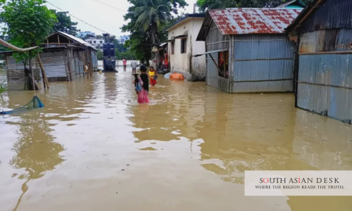
Bangladesh flood emergency is worsening as six rivers flow above danger levels and forecasters warn that at least two more days of heavy monsoon rain could trigger fresh flooding and landslides across vulnerable districts.
The Flood Forecasting and Warning Centre warned that river levels could rise further because of heavy rainfall expected in parts of Bangladesh and upstream Indian states, including Tripura, Meghalaya and West Bengal. The Bangladesh Meteorological Department has also forecast heavy to very heavy rain across large parts of the country as an active monsoon system continues through the weekend.
The situation has already left hundreds of thousands of people stranded, inundated homes and cropland, disrupted transport links, damaged goods, accelerated riverbank erosion and increased the risk of landslides in hill districts.
Bangladesh flood emergency enters critical phase
Bangladesh flood emergency has entered a critical phase as rising river levels spread the crisis from the southeastern hills to parts of the northeast and north.
According to the Flood Forecasting and Warning Centre, the Sangu, Matamuhuri, Kushiyara, Manu, Dhalai and Khowai rivers are flowing above danger level at one or more monitoring points. Additional upstream rainfall could worsen flooding in low-lying areas and riverbank communities.
The warning is significant because Bangladesh’s flood risk depends not only on local rainfall, but also on water flowing from upstream catchments. When heavy rain falls across northeastern India and the hill regions, river levels can rise rapidly across Bangladesh, leaving communities with little time to move people, livestock and belongings.
Forecasters have warned that the next two days may determine whether the current emergency develops into a wider flood crisis. With soil already saturated and rivers swollen, even moderate additional rainfall could worsen conditions in vulnerable areas.
Cox’s Bazar remains worst-hit district
Cox’s Bazar remains the worst-hit district, with more than 150,000 people affected and over 14,000 people sheltering in 640 cyclone and flood shelters.
Floodwaters rose again in several areas on Friday, leaving around 30,000 families marooned in more than 100 villages in Chakaria alone. The district has also faced repeated landslides in and around Rohingya refugee settlements, where steep hillsides, fragile shelters and overcrowding create severe monsoon risks.
The flood emergency turned fatal when a 12-year-old girl died after a rescue boat capsized while carrying residents to safety. The incident underlined the danger faced by both stranded families and rescue teams during evacuations.
The pressure on Cox’s Bazar is especially serious because the district is already managing one of the world’s largest refugee populations. Heavy rain can quickly destabilise slopes, damage shelters, interrupt camp services and complicate access for emergency responders.
Chittagong hit by waterlogging and transport disruption
In Chittagong, three consecutive days of torrential rain left large parts of the city under knee- to waist-deep water, disrupting businesses, schools and transport.
Although water has begun receding in some neighbourhoods, thousands of low-income families continue to struggle as floodwater remains inside homes and shops. For daily wage earners and small traders, even a few days of disruption can mean lost income, damaged stock and difficulty accessing food and clean water.
Train services between Chittagong and Cox’s Bazar remain suspended after sections of railway track were submerged. The disruption has affected travel, trade and emergency movement between one of Bangladesh’s most important port cities and its southern coastal districts.
Urban waterlogging has become a recurring problem during heavy rainfall. Poor drainage, rapid urbanisation and low-lying neighbourhoods can turn intense rain into a citywide disruption within hours.
Hill districts face renewed landslide risk
Meteorologists have warned that saturated soil has significantly increased the risk of fresh landslides in the hill districts.
Bandarban, Rangamati, Khagrachhari and parts of Chittagong are especially vulnerable because homes, roads and community structures are often located near unstable slopes. When rain continues for several days, hillside soil can loosen and collapse suddenly.
Rangamati remains under pressure as upstream runoff pushed the water level of Kaptai Lake to 90.31 feet, well above its seasonal operating level. More than 3,500 people are staying in shelters across the district.
The higher water level at Kaptai Lake has allowed the Kaptai Hydroelectric Power Plant to operate all five generating units, producing 179 megawatts of electricity. However, the same rise in water level also reflects the scale of runoff and rainfall affecting the region.
Officials have urged people living in flood- and landslide-prone areas to remain alert and move to safer locations where necessary.
Northeast and northern districts also under pressure
The crisis is not confined to the southeast. In Sunamganj, the Kushiyara River was flowing above danger level, threatening low-lying areas.
In Gaibandha and Bogra, riverbank erosion has accelerated, washing away farmland, homes and crops and forcing dozens of families to relocate. Riverbank erosion can be especially devastating because it destroys land permanently, leaving families without homes, fields or stable income sources.
At Benapole Land Port, flooding damaged imported goods worth crores of taka and disrupted operations. The incident shows that the impact of heavy rain is not limited to household displacement. It can also affect trade, logistics and supply chains.
The expansion of flood warnings across multiple regions shows how the active monsoon is creating a layered emergency: river flooding, urban waterlogging, landslides, erosion and transport disruption at the same time.
Heavy monsoon rain keeps threat active
The Bangladesh Meteorological Department recorded 329 millimetres of rainfall at Ambagan in Chittagong during the past 24 hours, the highest in the country. Kutubdia recorded 300 millimetres, Chittagong city 249 millimetres, Bandarban 235 millimetres, Rangamati 130 millimetres and Cox’s Bazar 125 millimetres.
Such heavy rainfall can rapidly overwhelm drainage systems, fill rivers and destabilise slopes. Very heavy rain is especially dangerous in the Chittagong Hill Tracts and Cox’s Bazar because steep terrain and fragile settlements increase the likelihood of flash flooding and landslides.
Meteorologists say the active monsoon shows little sign of weakening. That means the immediate priority for authorities will be evacuation, shelter management, road and rail restoration, food distribution and close monitoring of river levels.
The next 48 hours will be critical. If rainfall continues and upstream flows intensify, more districts may face flooding and displacement.
Emergency response needs rapid coordination
Authorities are already operating shelters in flood-hit districts, but the scale of the crisis may require rapid coordination between national agencies, local administrations, volunteers, health workers and disaster response teams.
Immediate needs include safe drinking water, cooked food, dry food, sanitation, medical support, emergency transport and protection for children, older people and people with disabilities. In shelters, overcrowding can quickly create health risks if clean water and sanitation are inadequate.
Road and rail disruptions also complicate relief delivery. When transport links are submerged or damaged, reaching isolated communities becomes slower and more expensive.
The government will also need to monitor the risk of waterborne diseases once floodwaters begin to recede. Standing water, damaged latrines and contaminated drinking sources can lead to diarrhoeal disease, skin infections and other health concerns.
Flood crisis exposes recurring monsoon vulnerability
Bangladesh flood emergency reflects the country’s recurring vulnerability to monsoon hazards. The combination of heavy rainfall, upstream river flows, dense settlements, fragile hillsides and low-lying land creates repeated disaster risks each year.
The current crisis has shown how quickly different hazards can overlap. Flooding in Cox’s Bazar and Chittagong has coincided with landslide risks in hill districts, riverbank erosion in the north, rising waters in the northeast and disruption at a major land port.
Long-term resilience will require stronger early warning systems, safer settlement planning, better drainage, improved river management, landslide risk mapping and stronger protection for communities living in high-risk areas.
For now, the immediate concern is preventing further loss of life. With six rivers already above danger level and more heavy monsoon rain forecast, Bangladesh remains on high alert as authorities warn that the worst of the current flood emergency may not yet be over.
Published in SouthAsianDesk, July 11, 2026
Follow SouthAsianDesk on X, Instagram and Facebook for insights on business and current affairs from across South Asia.